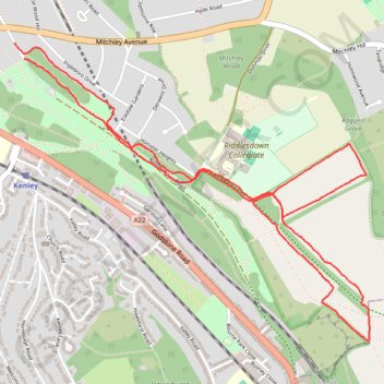
Riddlesdown Walk
- Distance: 3.7 mi
- Elevation gain: 210 ft
- Maximum elevation: 538 ft
- Elevation loss: 217 ft
- Minimum elevation: 433 ft
- Moving time: 1 h 10 m
- Moving speed: 3.1 mph
- Maximum speed: 5.8 mph
- Total time: 1 h 37 m
- Global speed: 2.3 mph
Interactive trail map
Trail profile
- Distance: 3.7 mi
- Elevation gain: 210 ft
- Maximum elevation: 538 ft
- Elevation loss: 217 ft
- Minimum elevation: 433 ft
- Moving time: 1 h 10 m
- Moving speed: 3.1 mph
- Maximum speed: 5.8 mph
- Total time: 1 h 37 m
- Global speed: 2.3 mph
About this trail
Name: Riddlesdown Walk trail, distance, elevation, map, profile, GPS track
Coordinates: 51.31817 -0.10156 51.33007 -0.07885