Make a donation
Gear up for your next adventure:
As an Amazon Associate, this site earns from qualifying purchases at no extra cost to you.
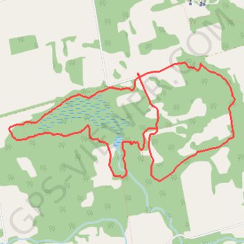
Nottawasaga Bluffs Trail
Interactive trail map
Make a donation
Gear up for your next adventure:
As an Amazon Associate, this site earns from qualifying purchases at no extra cost to you.
Trail profile
- Distance: 5.8 mi
- Elevation gain: 446 ft
- Maximum elevation: 1,736 ft
- Elevation loss: 446 ft
- Minimum elevation: 1,594 ft
Make a donation
Gear up for your next adventure:
As an Amazon Associate, this site earns from qualifying purchases at no extra cost to you.
About this trail
Name: Nottawasaga Bluffs Trail trail, distance, elevation, map, profile, GPS track
Coordinates: 44.33277 -80.22822 44.34420 -80.19784
Make a donation
Gear up for your next adventure:
As an Amazon Associate, this site earns from qualifying purchases at no extra cost to you.
Other hiking, mountain biking, running and outdoor activity trails
Click on a trail to view its statistics, map and profile.
Owen Sound - Orangeville
Canada > Ontario > Grey County > Owen Sound
Distance: 66.9 mi • Elevation gain: 1,946 ft • Maximum elevation: 1,696 ft
Keyhole Trail
Canada > Ontario > Simcoe County > Clearview
Distance: 3.5 mi • Elevation gain: 230 ft • Maximum elevation: 1,690 ft
Ontario country roads
Distance: 93.4 mi • Elevation gain: 3,730 ft • Maximum elevation: 1,631 ft