Pretty River Trail - Bruce Trail
Pretty River Valley Provincial Park. #Hiking #Snowshoeing #Loop #PrettyRiverValley
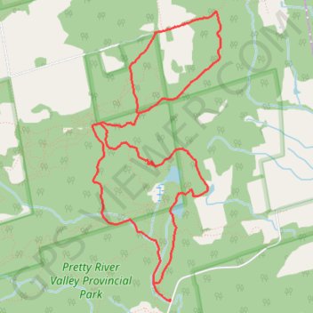
- Distance: 5.7 mi
- Elevation gain: 948 ft
- Maximum elevation: 1,713 ft
- Elevation loss: 948 ft
- Minimum elevation: 997 ft
Interactive trail map
Trail profile
- Distance: 5.7 mi
- Elevation gain: 948 ft
- Maximum elevation: 1,713 ft
- Elevation loss: 948 ft
- Minimum elevation: 997 ft
About this trail
Name: Pretty River Trail - Bruce Trail trail, distance, elevation, map, profile, GPS track
Start: 635244, Pretty River Road, The Blue Mountains, Grey County, Ontario, Canada (44.42366 -80.28862)
End: 635244, Pretty River Road, The Blue Mountains, Grey County, Ontario, Canada (44.42366 -80.28862)
Coordinates: 44.42347 -80.29745 44.44677 -80.28299
Other hiking, mountain biking, running and outdoor activity trails
Click on a trail to view its statistics, map and profile.
Owen Sound - Orangeville
Canada > Ontario > Grey County > Owen Sound
Distance: 66.9 mi • Elevation gain: 1,946 ft • Maximum elevation: 1,696 ft