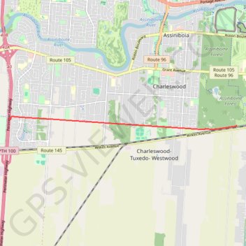
Import a GPX file

Harte Trail

#Hiking #Running

  • Distance: 7.9 mi
  • Elevation gain: 46 ft
  • Maximum elevation: 787 ft
  • Elevation loss: 46 ft
  • Minimum elevation: 771 ft

Interactive trail map

Trail profile

  • Distance: 7.9 mi
  • Elevation gain: 46 ft
  • Maximum elevation: 787 ft
  • Elevation loss: 46 ft
  • Minimum elevation: 771 ft

About this trail

Name: Harte Trail trail, distance, elevation, map, profile, GPS track

Start: Perimeter Highway, Ridgewood West, Winnipeg, Manitoba, R3R 2H3, Canada (49.84679 -97.32353)

End: Perimeter Highway, Ridgewood West, Winnipeg, Manitoba, R3R 2H3, Canada (49.84679 -97.32353)

Coordinates: 49.84425 -97.32353 49.84746 -97.23662

Gear up for your next adventure:

🥾Women's Hiking Boots - Top-rated trail boots with ankle support and superior grip
🔋Solar Power Banks - Keep your GPS and phone charged in remote wilderness areas
🌐World Map Poster - Decorative world maps with topographic info
🪶LED Camping Lantern - Bright lantern for camp lighting
🧭Outdoor Navigation Book - Learn advanced navigation skills

As an Amazon Associate, this site earns from qualifying purchases at no extra cost to you.