Thank you for supporting this site ❤️
Make a donation
Make a donation
Gear up for your next adventure:
As an Amazon Associate, this site earns from qualifying purchases at no extra cost to you.
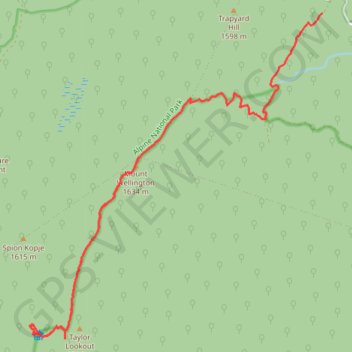
Mount Wellington Track GPX Trace
- Distance: 11.5 mi
- Elevation gain: 2,920 ft
- Maximum elevation: 5,348 ft
- Elevation loss: 1,660 ft
- Minimum elevation: 3,868 ft
- Moving time: 1 h 31 m
- Moving speed: 7.5 mph
- Maximum speed: 22.2 mph
- Total time: 2 h 58 m
- Global speed: 3.8 mph
Interactive trail map
Thank you for supporting this site ❤️
Make a donation
Make a donation
Gear up for your next adventure:
As an Amazon Associate, this site earns from qualifying purchases at no extra cost to you.
Trail profile
- Distance: 11.5 mi
- Elevation gain: 2,920 ft
- Maximum elevation: 5,348 ft
- Elevation loss: 1,660 ft
- Minimum elevation: 3,868 ft
- Moving time: 1 h 31 m
- Moving speed: 7.5 mph
- Maximum speed: 22.2 mph
- Total time: 2 h 58 m
- Global speed: 3.8 mph
Thank you for supporting this site ❤️
Make a donation
Make a donation
Gear up for your next adventure:
As an Amazon Associate, this site earns from qualifying purchases at no extra cost to you.
About this trail
Name: Mount Wellington Track GPX Trace trail, distance, elevation, map, profile, GPS track
Start: Mount Wellington Track, Moroka, Shire of Wellington, Victoria, Australia (-37.48161 146.88725)
Coordinates: -37.54072 146.82031 -37.48161 146.88725
Thank you for supporting this site ❤️
Make a donation
Make a donation
Gear up for your next adventure:
As an Amazon Associate, this site earns from qualifying purchases at no extra cost to you.
Other hiking, mountain biking, running and outdoor activity trails
Click on a trail to view its statistics, map and profile.