Wairakei Mountain Biking
Old Coach Road
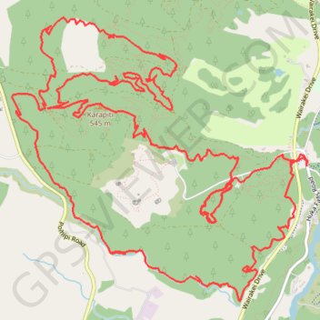
- Distance: 15.9 mi
- Elevation gain: 1,860 ft
- Maximum elevation: 1,765 ft
- Elevation loss: 1,854 ft
- Minimum elevation: 1,253 ft
- Moving time: 2 h 9 m
- Moving speed: 7.4 mph
- Maximum speed: 23.4 mph
- Total time: 2 h 30 m
- Global speed: 6.4 mph
Interactive trail map
Trail profile
- Distance: 15.9 mi
- Elevation gain: 1,860 ft
- Maximum elevation: 1,765 ft
- Elevation loss: 1,854 ft
- Minimum elevation: 1,253 ft
- Moving time: 2 h 9 m
- Moving speed: 7.4 mph
- Maximum speed: 23.4 mph
- Total time: 2 h 30 m
- Global speed: 6.4 mph
About this trail
Name: Wairakei Mountain Biking trail, distance, elevation, map, profile, GPS track
Start: 415, Huka Falls Road, Taupō District, Waikato, 3377, New Zealand (-38.64410 176.08766)
End: Huka Falls Road, Taupō District, Waikato, 3377, New Zealand (-38.64462 176.08776)
Coordinates: -38.65724 176.05282 -38.63089 176.08791