Make a donation
Gear up for your next adventure:
As an Amazon Associate, this site earns from qualifying purchases at no extra cost to you.
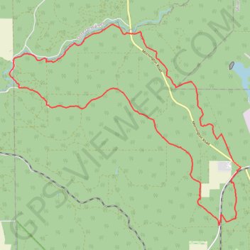
Herman road loop - New section of Mundabiddi trail
Morning Mountain Bike Ride
- Distance: 18.4 mi
- Elevation gain: 1,270 ft
- Maximum elevation: 928 ft
- Elevation loss: 1,266 ft
- Minimum elevation: 446 ft
- Moving time: 2 h 26 m
- Moving speed: 7.5 mph
- Maximum speed: 25.3 mph
- Total time: 3 h 2 m
- Global speed: 6.0 mph
Interactive trail map
Make a donation
Gear up for your next adventure:
As an Amazon Associate, this site earns from qualifying purchases at no extra cost to you.
Trail profile
- Distance: 18.4 mi
- Elevation gain: 1,270 ft
- Maximum elevation: 928 ft
- Elevation loss: 1,266 ft
- Minimum elevation: 446 ft
- Moving time: 2 h 26 m
- Moving speed: 7.5 mph
- Maximum speed: 25.3 mph
- Total time: 3 h 2 m
- Global speed: 6.0 mph
Make a donation
Gear up for your next adventure:
As an Amazon Associate, this site earns from qualifying purchases at no extra cost to you.
About this trail
Name: Herman road loop - New section of Mundabiddi trail trail, distance, elevation, map, profile, GPS track
Coordinates: -33.27645 115.94436 -33.21109 116.03429
Make a donation
Gear up for your next adventure:
As an Amazon Associate, this site earns from qualifying purchases at no extra cost to you.
Other hiking, mountain biking, running and outdoor activity trails
Click on a trail to view its statistics, map and profile.
Worsley railway line area Mountain Bike Ride
Australia > Western Australia > Worsley
Distance: 15.7 mi • Elevation gain: 1,171 ft • Maximum elevation: 873 ft
Mornington Road area Mountain Bike Ride
Australia > Western Australia > Worsley
Distance: 17.3 mi • Elevation gain: 1,063 ft • Maximum elevation: 919 ft
Big Tree road area MTB ride
Australia > Western Australia > Worsley
Fantastic Mountain Bike Ride
Distance: 25.1 mi • Elevation gain: 2,116 ft • Maximum elevation: 922 ft