Import a GPX file

Route von Oberalm nach/zu Gaisberg (1287 m)

  • Distance: 14.0 mi
  • Elevation gain: 2,986 ft
  • Maximum elevation: 4,219 ft
  • Elevation loss: 256 ft
  • Minimum elevation: 1,378 ft

Interactive trail map

Trail profile

  • Distance: 14.0 mi
  • Elevation gain: 2,986 ft
  • Maximum elevation: 4,219 ft
  • Elevation loss: 256 ft
  • Minimum elevation: 1,378 ft

About this trail
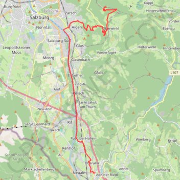
Name: Route von Oberalm nach/zu Gaisberg (1287 m) trail, distance, elevation, map, profile, GPS track

Start: 30, Hammerstraße, Oberalm, Bezirk Hallein, Salzburg, 5411, Austria (47.69334 13.10218)

End: Route 13, Gaisberg, Guggenthal, Salzburg, Bezirk Salzburg-Umgebung, Salzburg, 5321, Austria (47.80512 13.11273)

Coordinates: 47.69325 13.07038 47.80512 13.12361

Gear up for your next adventure:

Backpacking Tents - Weight-optimized shelters for multi-day topographic surveys
🛰️Handheld GPS Units - Professional satellite navigators for precise backcountry mapping
🌄Hiking Binoculars - Compact binoculars for scenic views and trail spotting
🏔️Mountain Trail Maps - High‑detail maps for popular peaks
🌧️Backpack Rain Cover - Keep gear dry in wet weather

As an Amazon Associate, this site earns from qualifying purchases at no extra cost to you.