Make a donation
Gear up for your next adventure:
As an Amazon Associate, this site earns from qualifying purchases at no extra cost to you.
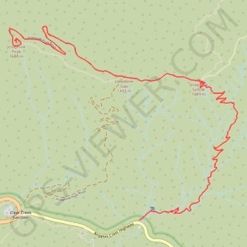
Josephine Peak
Hike to the Josephine Peak by the Colby Canyon, the Josephine Saddle and the Josephine Gap in the San Gabriel Mountains National Monument and the Angeles National Forest. #Hiking #Mountain #Nature #Canyon #Forest #River #Angeles
- Distance: 4.1 mi
- Elevation gain: 2,221 ft
- Maximum elevation: 5,469 ft
- Elevation loss: 279 ft
- Minimum elevation: 3,517 ft
Interactive trail map
Make a donation
Gear up for your next adventure:
As an Amazon Associate, this site earns from qualifying purchases at no extra cost to you.
Trail profile
- Distance: 4.1 mi
- Elevation gain: 2,221 ft
- Maximum elevation: 5,469 ft
- Elevation loss: 279 ft
- Minimum elevation: 3,517 ft
Make a donation
Gear up for your next adventure:
As an Amazon Associate, this site earns from qualifying purchases at no extra cost to you.
About this trail
Name: Josephine Peak trail, distance, elevation, map, profile, GPS track
Start: Angeles Crest Highway, Los Angeles County, California, United States (34.26975 -118.14067)
End: Josephine Peak Summit Trail, Los Angeles County, California, United States (34.28561 -118.15390)
Coordinates: 34.26975 -118.15467 34.28699 -118.13011
Topography: Los Angeles County topographic map, elevation, terrain
Make a donation
Gear up for your next adventure:
As an Amazon Associate, this site earns from qualifying purchases at no extra cost to you.