Make a donation
Gear up for your next adventure:
As an Amazon Associate, this site earns from qualifying purchases at no extra cost to you.
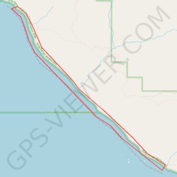
Lost Coast Trail
Interactive trail map
Make a donation
Gear up for your next adventure:
As an Amazon Associate, this site earns from qualifying purchases at no extra cost to you.
Trail profile
- Distance: 7.5 mi
- Elevation gain: 456 ft
- Maximum elevation: 236 ft
- Elevation loss: 456 ft
- Minimum elevation: 0 ft
Make a donation
Gear up for your next adventure:
As an Amazon Associate, this site earns from qualifying purchases at no extra cost to you.
About this trail
Name: Lost Coast Trail trail, distance, elevation, map, profile, GPS track
Start: Lost Coast Trail, Humboldt County, California, United States (40.23809 -124.33054)
End: Lost Coast Trail, Humboldt County, California, United States (40.23809 -124.33054)
Coordinates: 40.19976 -124.33054 40.23860 -124.28278
Topography: Humboldt County topographic map, elevation, terrain
Make a donation
Gear up for your next adventure:
As an Amazon Associate, this site earns from qualifying purchases at no extra cost to you.
Other hiking, mountain biking, running and outdoor activity trails
Click on a trail to view its statistics, map and profile.
Lost Coast Trail
United States > California > Humboldt County
From Mattole Beach, the Lost Coast Trail begins on an open Pacific shoreline where sand, dunes, driftwood and low coastal vegetation lead south toward Windy Point, the Punta Gorda Light area, Cooskie Creek and Randall Creek, with the King Range rising close behind the beach and giving the route its remote,…
Distance: 26.0 mi • Elevation gain: 2,356 ft • Maximum elevation: 174 ft