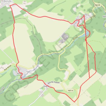
Jenneret
- Distance: 7.6 mi
- Elevation gain: 771 ft
- Maximum elevation: 994 ft
- Elevation loss: 997 ft
- Minimum elevation: 643 ft
Interactive trail map
Trail profile
- Distance: 7.6 mi
- Elevation gain: 771 ft
- Maximum elevation: 994 ft
- Elevation loss: 997 ft
- Minimum elevation: 643 ft
About this trail
Name: Jenneret trail, distance, elevation, map, profile, GPS track
Start: Bende, Durbuy, Marche-en-Famenne, Luxembourg, Wallonia, 6941, Belgium (50.39658 5.44941)
Coordinates: 50.39005 5.41536 50.41684 5.45223
Other hiking, mountain biking, running and outdoor activity trails
Click on a trail to view its statistics, map and profile.
Riethoven naar Oostenrijk
Netherlands > North Brabant > Riethoven > Eind
Distance: 573.0 mi • Elevation gain: 44,715 ft • Maximum elevation: 6,224 ft
Eurovelo 15 - Strasbourg Rotterdam
France > Grand Est > Bas-Rhin > Strasbourg
Distance: 554.1 mi • Elevation gain: 6,903 ft • Maximum elevation: 479 ft
LT25_FINAL
Belgium > Luxembourg > Bastogne > Mont
Distance: 171.5 mi • Elevation gain: 33,435 ft • Maximum elevation: 2,054 ft