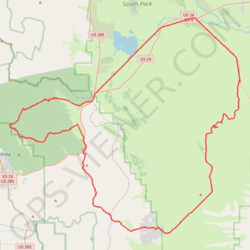
Next Step CO
- Distance: 82.6 mi
- Elevation gain: 6,512 ft
- Maximum elevation: 9,859 ft
- Elevation loss: 6,512 ft
- Minimum elevation: 8,438 ft
Interactive trail map
Trail profile
- Distance: 82.6 mi
- Elevation gain: 6,512 ft
- Maximum elevation: 9,859 ft
- Elevation loss: 6,512 ft
- Minimum elevation: 8,438 ft
About this trail
Name: Next Step CO trail, distance, elevation, map, profile, GPS track
Start: Dog Soldier Road, Park County, Colorado, United States (38.87691 -105.75868)
End: Dog Soldier Road, Park County, Colorado, United States (38.87691 -105.75865)
Coordinates: 38.73735 -106.11211 39.02344 -105.72044
Topography: Park County topographic map, elevation, terrain
Other hiking, mountain biking, running and outdoor activity trails
Click on a trail to view its statistics, map and profile.
Chalk Creek 2023 Race Lap
United States > Colorado > Chaffee County > Nathrop
Distance: 6.6 mi • Elevation gain: 568 ft • Maximum elevation: 8,041 ft