Thank you for supporting this site ❤️
Make a donation
Make a donation
Gear up for your next adventure:
As an Amazon Associate, this site earns from qualifying purchases at no extra cost to you.
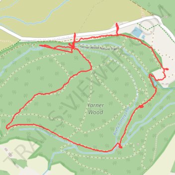
Winter hiking round trip around Yarner Old Reservoir in Dartmoor National Park
- Distance: 3.4 mi
- Elevation gain: 558 ft
- Maximum elevation: 801 ft
- Elevation loss: 554 ft
- Minimum elevation: 367 ft
- Moving time: 1 h 26 m
- Moving speed: 2.4 mph
- Maximum speed: 37.8 mph
- Total time: 2 h 3 m
- Global speed: 1.7 mph
Interactive trail map
Thank you for supporting this site ❤️
Make a donation
Make a donation
Gear up for your next adventure:
As an Amazon Associate, this site earns from qualifying purchases at no extra cost to you.
Trail profile
- Distance: 3.4 mi
- Elevation gain: 558 ft
- Maximum elevation: 801 ft
- Elevation loss: 554 ft
- Minimum elevation: 367 ft
- Moving time: 1 h 26 m
- Moving speed: 2.4 mph
- Maximum speed: 37.8 mph
- Total time: 2 h 3 m
- Global speed: 1.7 mph
Thank you for supporting this site ❤️
Make a donation
Make a donation
Gear up for your next adventure:
As an Amazon Associate, this site earns from qualifying purchases at no extra cost to you.
About this trail
Name: Winter hiking round trip around Yarner Old Reservoir in Dartmoor National Park trail, distance, elevation, map, profile, GPS track
Coordinates: 50.59185 -3.73414 50.60076 -3.71643
Thank you for supporting this site ❤️
Make a donation
Make a donation
Gear up for your next adventure:
As an Amazon Associate, this site earns from qualifying purchases at no extra cost to you.