Thank you for supporting this site ❤️
Make a donation
Make a donation
Gear up for your next adventure:
As an Amazon Associate, this site earns from qualifying purchases at no extra cost to you.
Blyth Hut
19-JUN-07
- Distance: 15.2 mi
- Elevation gain: 2,776 ft
- Maximum elevation: 5,669 ft
- Elevation loss: 5,118 ft
- Minimum elevation: 3,018 ft
Interactive trail map
Thank you for supporting this site ❤️
Make a donation
Make a donation
Gear up for your next adventure:
As an Amazon Associate, this site earns from qualifying purchases at no extra cost to you.
Trail profile
- Distance: 15.2 mi
- Elevation gain: 2,776 ft
- Maximum elevation: 5,669 ft
- Elevation loss: 5,118 ft
- Minimum elevation: 3,018 ft
Thank you for supporting this site ❤️
Make a donation
Make a donation
Gear up for your next adventure:
As an Amazon Associate, this site earns from qualifying purchases at no extra cost to you.
About this trail
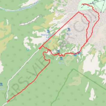
Name: Blyth Hut trail, distance, elevation, map, profile, GPS track
Coordinates: -39.35992 175.47227 -39.30423 175.53983
Thank you for supporting this site ❤️
Make a donation
Make a donation
Gear up for your next adventure:
As an Amazon Associate, this site earns from qualifying purchases at no extra cost to you.
Other hiking, mountain biking, running and outdoor activity trails
Click on a trail to view its statistics, map and profile.