Thank you for supporting this site ❤️
Make a donation
Make a donation
Gear up for your next adventure:
As an Amazon Associate, this site earns from qualifying purchases at no extra cost to you.
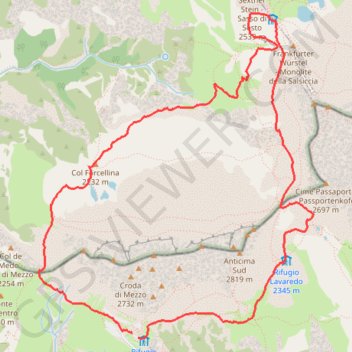
Move
- Distance: 6.2 mi
- Elevation gain: 1,467 ft
- Maximum elevation: 8,005 ft
- Elevation loss: 1,470 ft
- Minimum elevation: 7,126 ft
- Moving time: 4 h 52 m
- Moving speed: 1.3 mph
- Maximum speed: 3.4 mph
- Total time: 5 h 29 m
- Global speed: 1.1 mph
Interactive trail map
Thank you for supporting this site ❤️
Make a donation
Make a donation
Gear up for your next adventure:
As an Amazon Associate, this site earns from qualifying purchases at no extra cost to you.
Trail profile
- Distance: 6.2 mi
- Elevation gain: 1,467 ft
- Maximum elevation: 8,005 ft
- Elevation loss: 1,470 ft
- Minimum elevation: 7,126 ft
- Moving time: 4 h 52 m
- Moving speed: 1.3 mph
- Maximum speed: 3.4 mph
- Total time: 5 h 29 m
- Global speed: 1.1 mph
Thank you for supporting this site ❤️
Make a donation
Make a donation
Gear up for your next adventure:
As an Amazon Associate, this site earns from qualifying purchases at no extra cost to you.
About this trail
Name: Move trail, distance, elevation, map, profile, GPS track
Coordinates: 46.61230 12.28431 46.63737 12.31514
Thank you for supporting this site ❤️
Make a donation
Make a donation
Gear up for your next adventure:
As an Amazon Associate, this site earns from qualifying purchases at no extra cost to you.