Make a donation
Gear up for your next adventure:
As an Amazon Associate, this site earns from qualifying purchases at no extra cost to you.
Mount Bierstadt in Mount Evans Wilderness
The Mount Bierstadt trail takes you through the stunning alpine landscape of the Mount Blue Sky wilderness area, where you'll experience a steady ascent that keeps you on your toes. As you climb, the air grows thinner, and the breathtaking views of the Front Range. Though the hike becomes increasingly challenging near the summit, the reward of standing atop one of Colorado's iconic fourteeners, with its panoramic vistas, makes every step worthwhile! #Hiking #Mountain #Forest #Nature #Lake
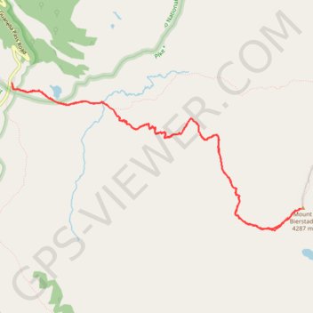
- Distance: 7.2 mi
- Elevation gain: 2,677 ft
- Maximum elevation: 14,039 ft
- Elevation loss: 2,674 ft
- Minimum elevation: 11,499 ft
- Moving time: 3 h 38 m
- Moving speed: 2.0 mph
- Maximum speed: 3.8 mph
- Total time: 4 h 54 m
- Global speed: 1.5 mph
Interactive trail map
Make a donation
Gear up for your next adventure:
As an Amazon Associate, this site earns from qualifying purchases at no extra cost to you.
Trail profile
- Distance: 7.2 mi
- Elevation gain: 2,677 ft
- Maximum elevation: 14,039 ft
- Elevation loss: 2,674 ft
- Minimum elevation: 11,499 ft
- Moving time: 3 h 38 m
- Moving speed: 2.0 mph
- Maximum speed: 3.8 mph
- Total time: 4 h 54 m
- Global speed: 1.5 mph
Make a donation
Gear up for your next adventure:
As an Amazon Associate, this site earns from qualifying purchases at no extra cost to you.
About this trail
Name: Mount Bierstadt in Mount Evans Wilderness trail, distance, elevation, map, profile, GPS track
Start: Mount Bierstadt Trail, Clear Creek County, Colorado, United States (39.59637 -105.71022)
End: Mount Bierstadt Trail, Clear Creek County, Colorado, United States (39.59611 -105.71016)
Coordinates: 39.58012 -105.71026 39.59637 -105.66887
Topography: Clear Creek County topographic map, elevation, terrain
Make a donation
Gear up for your next adventure:
As an Amazon Associate, this site earns from qualifying purchases at no extra cost to you.
Other hiking, mountain biking, running and outdoor activity trails
Click on a trail to view its statistics, map and profile.
Mount Bierstadt Trail in Mount Evans Wilderness
United States > Colorado > Clear Creek County
The Mount Bierstadt Trail offers a fantastic opportunity to summit one of Colorado's iconic 14ers with relatively moderate difficulty. Starting from the Guanella Pass Trailhead, the route takes hikers through alpine meadows, crossing wooden bridges over Scott Gomer Creek, and gradually ascending toward the…
Distance: 3.7 mi • Elevation gain: 2,549 ft • Maximum elevation: 14,035 ft