Make a donation
Gear up for your next adventure:
As an Amazon Associate, this site earns from qualifying purchases at no extra cost to you.
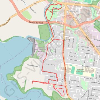
Loop to Capalaba Regional Park
- Distance: 6.6 mi
- Elevation gain: 427 ft
- Maximum elevation: 187 ft
- Elevation loss: 420 ft
- Minimum elevation: 13 ft
- Moving time: 58 m 45 s
- Moving speed: 6.8 mph
- Maximum speed: 9.5 mph
- Total time: 58 m 45 s
- Global speed: 6.8 mph
Interactive trail map
Make a donation
Gear up for your next adventure:
As an Amazon Associate, this site earns from qualifying purchases at no extra cost to you.
Trail profile
- Distance: 6.6 mi
- Elevation gain: 427 ft
- Maximum elevation: 187 ft
- Elevation loss: 420 ft
- Minimum elevation: 13 ft
- Moving time: 58 m 45 s
- Moving speed: 6.8 mph
- Maximum speed: 9.5 mph
- Total time: 58 m 45 s
- Global speed: 6.8 mph
Make a donation
Gear up for your next adventure:
As an Amazon Associate, this site earns from qualifying purchases at no extra cost to you.
About this trail
Name: Loop to Capalaba Regional Park trail, distance, elevation, map, profile, GPS track
Start: Howlett Road, Capalaba, Greater Brisbane, Queensland, 4157, Australia (-27.53898 153.18109)
End: Howlett Road, Capalaba, Greater Brisbane, Queensland, 4157, Australia (-27.53930 153.18081)
Coordinates: -27.54241 153.18080 -27.52038 153.19036
Make a donation
Gear up for your next adventure:
As an Amazon Associate, this site earns from qualifying purchases at no extra cost to you.
Other hiking, mountain biking, running and outdoor activity trails
Click on a trail to view its statistics, map and profile.
Capalaba and Alex Hills loop
Distance: 13.2 mi • Elevation gain: 820 ft • Maximum elevation: 187 ft