Munro Hillwalk Fionn Bheinn
Munro, Hillwalk, Fionn, Bheinn
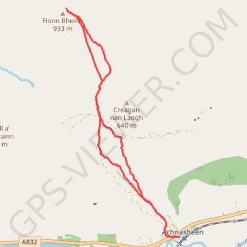
- Distance: 5.8 mi
- Elevation gain: 2,552 ft
- Maximum elevation: 3,045 ft
- Elevation loss: 2,549 ft
- Minimum elevation: 492 ft
- Moving time: 2 h 59 m
- Moving speed: 1.9 mph
- Maximum speed: 3.9 mph
- Total time: 3 h 29 m
- Global speed: 1.7 mph
Interactive trail map
Trail profile
- Distance: 5.8 mi
- Elevation gain: 2,552 ft
- Maximum elevation: 3,045 ft
- Elevation loss: 2,549 ft
- Minimum elevation: 492 ft
- Moving time: 2 h 59 m
- Moving speed: 1.9 mph
- Maximum speed: 3.9 mph
- Total time: 3 h 29 m
- Global speed: 1.7 mph
About this trail
Name: Munro Hillwalk Fionn Bheinn trail, distance, elevation, map, profile, GPS track
Start: Station Road, Achnasheen, Highland, Scotland, IV22 2EG, United Kingdom (57.57941 -5.07321)
Coordinates: 57.57936 -5.10269 57.61115 -5.07321