Thank you for supporting this site ❤️
Make a donation
Make a donation
Gear up for your next adventure:
As an Amazon Associate, this site earns from qualifying purchases at no extra cost to you.
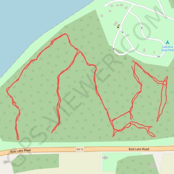
Lake Erie State Park Trail
Hiking
- Distance: 2.5 mi
- Elevation gain: 105 ft
- Maximum elevation: 630 ft
- Elevation loss: 102 ft
- Minimum elevation: 577 ft
- Moving time: 59 m 11 s
- Moving speed: 2.6 mph
- Maximum speed: 4.9 mph
- Total time: 1 h 6 m
- Global speed: 2.3 mph
Interactive trail map
Thank you for supporting this site ❤️
Make a donation
Make a donation
Gear up for your next adventure:
As an Amazon Associate, this site earns from qualifying purchases at no extra cost to you.
Trail profile
- Distance: 2.5 mi
- Elevation gain: 105 ft
- Maximum elevation: 630 ft
- Elevation loss: 102 ft
- Minimum elevation: 577 ft
- Moving time: 59 m 11 s
- Moving speed: 2.6 mph
- Maximum speed: 4.9 mph
- Total time: 1 h 6 m
- Global speed: 2.3 mph
Thank you for supporting this site ❤️
Make a donation
Make a donation
Gear up for your next adventure:
As an Amazon Associate, this site earns from qualifying purchases at no extra cost to you.
About this trail
Name: Lake Erie State Park Trail trail, distance, elevation, map, profile, GPS track
Coordinates: 42.41939 -79.43958 42.42261 -79.43298
Topography: Chautauqua County topographic map, elevation, terrain
Thank you for supporting this site ❤️
Make a donation
Make a donation
Gear up for your next adventure:
As an Amazon Associate, this site earns from qualifying purchases at no extra cost to you.