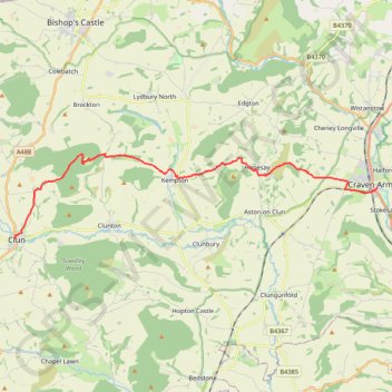
Clun to Craven Arms
- Distance: 11.8 mi
- Elevation gain: 1,608 ft
- Maximum elevation: 1,283 ft
- Elevation loss: 1,841 ft
- Minimum elevation: 394 ft
- Moving time: 5 h 23 m
- Moving speed: 2.2 mph
- Maximum speed: 3.5 mph
- Total time: 6 h 57 m
- Global speed: 1.7 mph
Interactive trail map
Trail profile
- Distance: 11.8 mi
- Elevation gain: 1,608 ft
- Maximum elevation: 1,283 ft
- Elevation loss: 1,841 ft
- Minimum elevation: 394 ft
- Moving time: 5 h 23 m
- Moving speed: 2.2 mph
- Maximum speed: 3.5 mph
- Total time: 6 h 57 m
- Global speed: 1.7 mph
About this trail
Name: Clun to Craven Arms trail, distance, elevation, map, profile, GPS track
Start: Enfield Street, Clun, Shropshire, England, SY7 8JS, United Kingdom (52.42161 -3.03039)
Coordinates: 52.42140 -3.03086 52.44976 -2.83269
Other hiking, mountain biking, running and outdoor activity trails
Click on a trail to view its statistics, map and profile.
Bishops Castle to Clun
United Kingdom > England > Shropshire > Bishop's Castle
Distance: 12.9 mi • Elevation gain: 1,988 ft • Maximum elevation: 1,322 ft