Thank you for supporting this site ❤️
Make a donation
Make a donation
Gear up for your next adventure:
As an Amazon Associate, this site earns from qualifying purchases at no extra cost to you.
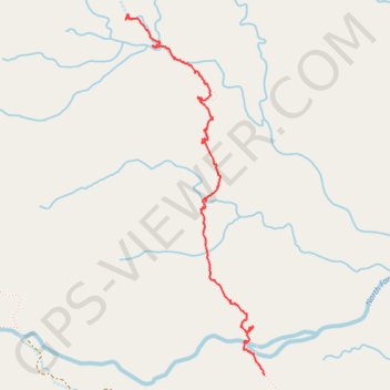
Water tunnels
- Distance: 2.6 mi
- Elevation gain: 623 ft
- Maximum elevation: 1,266 ft
- Elevation loss: 299 ft
- Minimum elevation: 856 ft
- Moving time: 1 h 57 m
- Moving speed: 1.3 mph
- Maximum speed: 13.7 mph
- Total time: 5 h 33 m
- Global speed: 0.5 mph
Interactive trail map
Thank you for supporting this site ❤️
Make a donation
Make a donation
Gear up for your next adventure:
As an Amazon Associate, this site earns from qualifying purchases at no extra cost to you.
Trail profile
- Distance: 2.6 mi
- Elevation gain: 623 ft
- Maximum elevation: 1,266 ft
- Elevation loss: 299 ft
- Minimum elevation: 856 ft
- Moving time: 1 h 57 m
- Moving speed: 1.3 mph
- Maximum speed: 13.7 mph
- Total time: 5 h 33 m
- Global speed: 0.5 mph
Thank you for supporting this site ❤️
Make a donation
Make a donation
Gear up for your next adventure:
As an Amazon Associate, this site earns from qualifying purchases at no extra cost to you.
About this trail
Name: Water tunnels trail, distance, elevation, map, profile, GPS track
Start: Kauaʻi County, Hawaii, United States (22.06040 -159.45306)
End: Kauaʻi County, Hawaii, United States (22.08081 -159.46115)
Coordinates: 22.06040 -159.46162 22.08105 -159.45306
Topography: Kauaʻi County topographic map, elevation, terrain
Thank you for supporting this site ❤️
Make a donation
Make a donation
Gear up for your next adventure:
As an Amazon Associate, this site earns from qualifying purchases at no extra cost to you.