Thank you for supporting this site ❤️
Make a donation
Make a donation
Gear up for your next adventure:
As an Amazon Associate, this site earns from qualifying purchases at no extra cost to you.
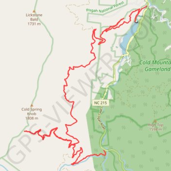
Cold Mountain forest service roads
- Distance: 18.2 mi
- Elevation gain: 4,803 ft
- Maximum elevation: 5,551 ft
- Elevation loss: 4,518 ft
- Minimum elevation: 2,877 ft
- Moving time: 4 h 27 m
- Moving speed: 4.1 mph
- Maximum speed: 10.2 mph
- Total time: 4 h 37 m
- Global speed: 3.9 mph
Interactive trail map
Thank you for supporting this site ❤️
Make a donation
Make a donation
Gear up for your next adventure:
As an Amazon Associate, this site earns from qualifying purchases at no extra cost to you.
Trail profile
- Distance: 18.2 mi
- Elevation gain: 4,803 ft
- Maximum elevation: 5,551 ft
- Elevation loss: 4,518 ft
- Minimum elevation: 2,877 ft
- Moving time: 4 h 27 m
- Moving speed: 4.1 mph
- Maximum speed: 10.2 mph
- Total time: 4 h 37 m
- Global speed: 3.9 mph
Thank you for supporting this site ❤️
Make a donation
Make a donation
Gear up for your next adventure:
As an Amazon Associate, this site earns from qualifying purchases at no extra cost to you.
About this trail
Name: Cold Mountain forest service roads trail, distance, elevation, map, profile, GPS track
Start: Lake Logan Road, Haywood County, North Carolina, United States (35.42738 -82.91998)
Coordinates: 35.36809 -82.97626 35.42738 -82.91998
Topography: Haywood County topographic map, elevation, terrain
Thank you for supporting this site ❤️
Make a donation
Make a donation
Gear up for your next adventure:
As an Amazon Associate, this site earns from qualifying purchases at no extra cost to you.