Thank you for supporting this site ❤️
Make a donation
Make a donation
Gear up for your next adventure:
As an Amazon Associate, this site earns from qualifying purchases at no extra cost to you.
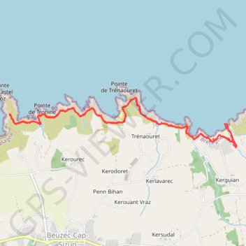
Bretagne 7
- Distance: 5.4 mi
- Elevation gain: 1,122 ft
- Maximum elevation: 135 ft
- Elevation loss: 1,050 ft
- Minimum elevation: 0 ft
- Moving time: 2 h 41 m
- Moving speed: 2.0 mph
- Maximum speed: 4.4 mph
- Total time: 4 h 10 s
- Global speed: 1.4 mph
Interactive trail map
Thank you for supporting this site ❤️
Make a donation
Make a donation
Gear up for your next adventure:
As an Amazon Associate, this site earns from qualifying purchases at no extra cost to you.
Trail profile
- Distance: 5.4 mi
- Elevation gain: 1,122 ft
- Maximum elevation: 135 ft
- Elevation loss: 1,050 ft
- Minimum elevation: 0 ft
- Moving time: 2 h 41 m
- Moving speed: 2.0 mph
- Maximum speed: 4.4 mph
- Total time: 4 h 10 s
- Global speed: 1.4 mph
Thank you for supporting this site ❤️
Make a donation
Make a donation
Gear up for your next adventure:
As an Amazon Associate, this site earns from qualifying purchases at no extra cost to you.
About this trail
Name: Bretagne 7 trail, distance, elevation, map, profile, GPS track
Coordinates: 48.08519 -4.52052 48.09032 -4.48521
Thank you for supporting this site ❤️
Make a donation
Make a donation
Gear up for your next adventure:
As an Amazon Associate, this site earns from qualifying purchases at no extra cost to you.