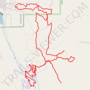
Santaquin Canyon MTB trails - Uinta-Wasatch-Cache National Forest
- Distance: 11.7 mi
- Elevation gain: 2,575 ft
- Maximum elevation: 6,591 ft
- Elevation loss: 2,572 ft
- Minimum elevation: 5,269 ft
- Moving time: 2 h 29 m
- Moving speed: 4.7 mph
- Maximum speed: 24.2 mph
- Total time: 2 h 48 m
- Global speed: 4.2 mph
Interactive trail map
Trail profile
- Distance: 11.7 mi
- Elevation gain: 2,575 ft
- Maximum elevation: 6,591 ft
- Elevation loss: 2,572 ft
- Minimum elevation: 5,269 ft
- Moving time: 2 h 29 m
- Moving speed: 4.7 mph
- Maximum speed: 24.2 mph
- Total time: 2 h 48 m
- Global speed: 4.2 mph
About this trail
Name: Santaquin Canyon MTB trails - Uinta-Wasatch-Cache National Forest trail, distance, elevation, map, profile, GPS track
Start: Silver King Trail, Utah County, Utah, 84655, United States (39.93925 -111.76846)
End: Silver King Trail, Utah County, Utah, 84655, United States (39.93925 -111.76842)
Coordinates: 39.93594 -111.77487 39.96055 -111.75191
Topography: Utah County topographic map, elevation, terrain