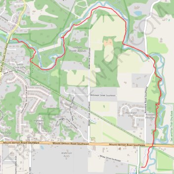
Sac & Fox Trail run/walk
- Distance: 3.4 mi
- Elevation gain: 121 ft
- Maximum elevation: 761 ft
- Elevation loss: 108 ft
- Minimum elevation: 715 ft
- Moving time: 39 m 7 s
- Moving speed: 5.2 mph
- Maximum speed: 16.5 mph
- Total time: 41 m 15 s
- Global speed: 5.0 mph
Interactive trail map
Trail profile
- Distance: 3.4 mi
- Elevation gain: 121 ft
- Maximum elevation: 761 ft
- Elevation loss: 108 ft
- Minimum elevation: 715 ft
- Moving time: 39 m 7 s
- Moving speed: 5.2 mph
- Maximum speed: 16.5 mph
- Total time: 41 m 15 s
- Global speed: 5.0 mph
About this trail
Name: Sac & Fox Trail run/walk trail, distance, elevation, map, profile, GPS track
Start: Sac & Fox Trail, Vernon View, Linn County, Iowa, 39198, United States (41.97371 -91.58013)
End: Sac & Fox Trail, Linn County, Iowa, 39198, United States (41.98993 -91.60212)
Coordinates: 41.97371 -91.60212 41.99410 -91.57670
Topography: Linn County topographic map, elevation, terrain