ציורי הסלע, הטומולוסים והר ערקוב
- Distance: 5.8 mi
- Elevation gain: 761 ft
- Maximum elevation: 2,139 ft
- Elevation loss: 761 ft
- Minimum elevation: 1,703 ft
- Moving time: 1 h 40 m
- Moving speed: 3.5 mph
- Maximum speed: 20.4 mph
- Total time: 1 h 51 m
- Global speed: 3.1 mph
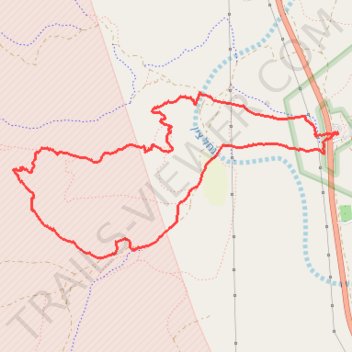
Interactive trail map
Trail profile
- Distance: 5.8 mi
- Elevation gain: 761 ft
- Maximum elevation: 2,139 ft
- Elevation loss: 761 ft
- Minimum elevation: 1,703 ft
- Moving time: 1 h 40 m
- Moving speed: 3.5 mph
- Maximum speed: 20.4 mph
- Total time: 1 h 51 m
- Global speed: 3.1 mph
About this trail
Name: ציורי הסלע, הטומולוסים והר ערקוב trail, distance, elevation, map, profile, GPS track
Start: 40, Ramat Negev Regional Council, Beersheba Subdistrict, South District, Israel (30.79234 34.76861)
End: 40, Ramat Negev Regional Council, Beersheba Subdistrict, South District, Israel (30.79225 34.76868)
Coordinates: 30.78230 34.73829 30.79551 34.76868