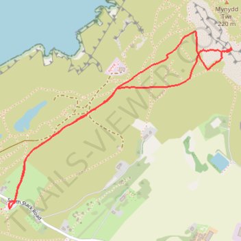
Mynydd Tŵr, Caergybi
- Distance: 1.9 mi
- Elevation gain: 364 ft
- Maximum elevation: 531 ft
- Elevation loss: 364 ft
- Minimum elevation: 308 ft
- Moving time: 58 m
- Moving speed: 2.0 mph
- Maximum speed: 16.2 mph
- Total time: 3 h 51 m
- Global speed: 0.5 mph
Interactive trail map
Trail profile
- Distance: 1.9 mi
- Elevation gain: 364 ft
- Maximum elevation: 531 ft
- Elevation loss: 364 ft
- Minimum elevation: 308 ft
- Moving time: 58 m
- Moving speed: 2.0 mph
- Maximum speed: 16.2 mph
- Total time: 3 h 51 m
- Global speed: 0.5 mph
About this trail
Name: Mynydd Tŵr, Caergybi trail, distance, elevation, map, profile, GPS track
Start: South Stack Road, Trearddur, Isle of Anglesey, Wales, LL65 1YH, United Kingdom (53.30480 -4.69061)
End: South Stack Road, Trearddur, Isle of Anglesey, Wales, LL65 1YH, United Kingdom (53.30480 -4.69061)
Coordinates: 53.30480 -4.69066 53.31218 -4.67524