Make a donation
Gear up for your next adventure:
As an Amazon Associate, this site earns from qualifying purchases at no extra cost to you.
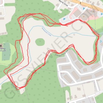
Old Mill Pond Trail loop
Evening Run
- Distance: 3.6 mi
- Elevation gain: 207 ft
- Maximum elevation: 315 ft
- Elevation loss: 197 ft
- Minimum elevation: 276 ft
- Moving time: 34 m 58 s
- Moving speed: 6.1 mph
- Maximum speed: 24.2 mph
- Total time: 34 m 58 s
- Global speed: 6.1 mph
Interactive trail map
Make a donation
Gear up for your next adventure:
As an Amazon Associate, this site earns from qualifying purchases at no extra cost to you.
Trail profile
- Distance: 3.6 mi
- Elevation gain: 207 ft
- Maximum elevation: 315 ft
- Elevation loss: 197 ft
- Minimum elevation: 276 ft
- Moving time: 34 m 58 s
- Moving speed: 6.1 mph
- Maximum speed: 24.2 mph
- Total time: 34 m 58 s
- Global speed: 6.1 mph
Make a donation
Gear up for your next adventure:
As an Amazon Associate, this site earns from qualifying purchases at no extra cost to you.
About this trail
Name: Old Mill Pond Trail loop trail, distance, elevation, map, profile, GPS track
Coordinates: 33.97334 -81.23493 33.97741 -81.22881
Topography: Lexington County topographic map, elevation, terrain
Make a donation
Gear up for your next adventure:
As an Amazon Associate, this site earns from qualifying purchases at no extra cost to you.
Other hiking, mountain biking, running and outdoor activity trails
Click on a trail to view its statistics, map and profile.
Old Mill Pond Trail around Lexington Mill Pond
United States > South Carolina > Lexington County > Lexington
Distance: 1.3 mi • Elevation gain: 56 ft • Maximum elevation: 312 ft