Thank you for supporting this site ❤️
Make a donation
Make a donation
Gear up for your next adventure:
As an Amazon Associate, this site earns from qualifying purchases at no extra cost to you.
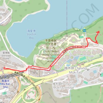
年華路小山
Hiking
- Distance: 1.7 mi
- Elevation gain: 121 ft
- Maximum elevation: 95 ft
- Elevation loss: 125 ft
- Minimum elevation: 20 ft
- Moving time: 48 m 38 s
- Moving speed: 2.1 mph
- Maximum speed: 3.1 mph
- Total time: 1 h 29 m
- Global speed: 1.1 mph
Interactive trail map
Thank you for supporting this site ❤️
Make a donation
Make a donation
Gear up for your next adventure:
As an Amazon Associate, this site earns from qualifying purchases at no extra cost to you.
Trail profile
- Distance: 1.7 mi
- Elevation gain: 121 ft
- Maximum elevation: 95 ft
- Elevation loss: 125 ft
- Minimum elevation: 20 ft
- Moving time: 48 m 38 s
- Moving speed: 2.1 mph
- Maximum speed: 3.1 mph
- Total time: 1 h 29 m
- Global speed: 1.1 mph
Thank you for supporting this site ❤️
Make a donation
Make a donation
Gear up for your next adventure:
As an Amazon Associate, this site earns from qualifying purchases at no extra cost to you.
About this trail
Name: 年華路小山 trail, distance, elevation, map, profile, GPS track
Coordinates: 22.42961 114.24384 22.43300 114.25258
Thank you for supporting this site ❤️
Make a donation
Make a donation
Gear up for your next adventure:
As an Amazon Associate, this site earns from qualifying purchases at no extra cost to you.
Other hiking, mountain biking, running and outdoor activity trails
Click on a trail to view its statistics, map and profile.
Wilson Trail Full Route
China > Hong Kong > Hong Kong Island
Distance: 50.5 mi • Elevation gain: 14,534 ft • Maximum elevation: 2,011 ft