Make a donation
Gear up for your next adventure:
As an Amazon Associate, this site earns from qualifying purchases at no extra cost to you.
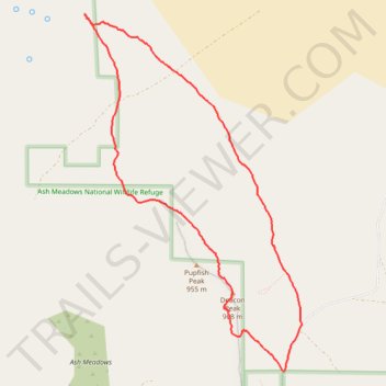
Ash Meadows National Wildlife Refuge: Longstreet Peak - Deacon Peak Loop Hike
- Distance: 6.7 mi
- Elevation gain: 1,257 ft
- Maximum elevation: 3,136 ft
- Elevation loss: 1,253 ft
- Minimum elevation: 2,388 ft
- Moving time: 2 h 53 m
- Moving speed: 2.3 mph
- Maximum speed: 5.2 mph
- Total time: 3 h 13 m
- Global speed: 2.1 mph
Interactive trail map
Make a donation
Gear up for your next adventure:
As an Amazon Associate, this site earns from qualifying purchases at no extra cost to you.
Trail profile
- Distance: 6.7 mi
- Elevation gain: 1,257 ft
- Maximum elevation: 3,136 ft
- Elevation loss: 1,253 ft
- Minimum elevation: 2,388 ft
- Moving time: 2 h 53 m
- Moving speed: 2.3 mph
- Maximum speed: 5.2 mph
- Total time: 3 h 13 m
- Global speed: 2.1 mph
Make a donation
Gear up for your next adventure:
As an Amazon Associate, this site earns from qualifying purchases at no extra cost to you.
About this trail
Name: Ash Meadows National Wildlife Refuge: Longstreet Peak - Deacon Peak Loop Hike trail, distance, elevation, map, profile, GPS track
Start: Devils Hole Road, Nye County, Nevada, United States (36.42794 -116.28812)
End: Devils Hole Road, Nye County, Nevada, United States (36.42808 -116.28835)
Coordinates: 36.42794 -116.31280 36.46348 -116.28592
Topography: Nye County topographic map, elevation, terrain
Make a donation
Gear up for your next adventure:
As an Amazon Associate, this site earns from qualifying purchases at no extra cost to you.