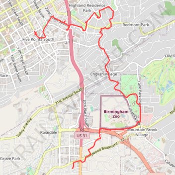
Walking Five Points, Highland Park, Key Circle, Botanical Gardens, Mountain Brook Village
- Distance: 5.7 mi
- Elevation gain: 515 ft
- Maximum elevation: 971 ft
- Elevation loss: 469 ft
- Minimum elevation: 663 ft
- Moving time: 2 h 31 m
- Moving speed: 2.3 mph
- Maximum speed: 6.2 mph
- Total time: 3 h 46 m
- Global speed: 1.5 mph
Interactive trail map
Trail profile
- Distance: 5.7 mi
- Elevation gain: 515 ft
- Maximum elevation: 971 ft
- Elevation loss: 469 ft
- Minimum elevation: 663 ft
- Moving time: 2 h 31 m
- Moving speed: 2.3 mph
- Maximum speed: 6.2 mph
- Total time: 3 h 46 m
- Global speed: 1.5 mph
About this trail
Name: Walking Five Points, Highland Park, Key Circle, Botanical Gardens, Mountain Brook Village trail, distance, elevation, map, profile, GPS track
Coordinates: 33.47718 -86.79718 33.50645 -86.77417
Topography: Birmingham topographic map, elevation, terrain