Thank you for supporting this site ❤️
Make a donation
Make a donation
Gear up for your next adventure:
As an Amazon Associate, this site earns from qualifying purchases at no extra cost to you.
Rum river forest
- Distance: 2.0 mi
- Elevation gain: 66 ft
- Maximum elevation: 1,234 ft
- Elevation loss: 66 ft
- Minimum elevation: 1,211 ft
- Moving time: 13 m 15 s
- Moving speed: 9.0 mph
- Maximum speed: 20.0 mph
- Total time: 13 m 15 s
- Global speed: 9.0 mph
Interactive trail map
Thank you for supporting this site ❤️
Make a donation
Make a donation
Gear up for your next adventure:
As an Amazon Associate, this site earns from qualifying purchases at no extra cost to you.
Trail profile
- Distance: 2.0 mi
- Elevation gain: 66 ft
- Maximum elevation: 1,234 ft
- Elevation loss: 66 ft
- Minimum elevation: 1,211 ft
- Moving time: 13 m 15 s
- Moving speed: 9.0 mph
- Maximum speed: 20.0 mph
- Total time: 13 m 15 s
- Global speed: 9.0 mph
Thank you for supporting this site ❤️
Make a donation
Make a donation
Gear up for your next adventure:
As an Amazon Associate, this site earns from qualifying purchases at no extra cost to you.
About this trail
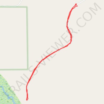
Name: Rum river forest trail, distance, elevation, map, profile, GPS track
Coordinates: 45.91154 -93.59183 45.92284 -93.58322
Topography: Mudgett Township topographic map, elevation, terrain
Thank you for supporting this site ❤️
Make a donation
Make a donation
Gear up for your next adventure:
As an Amazon Associate, this site earns from qualifying purchases at no extra cost to you.