Make a donation
Gear up for your next adventure:
As an Amazon Associate, this site earns from qualifying purchases at no extra cost to you.
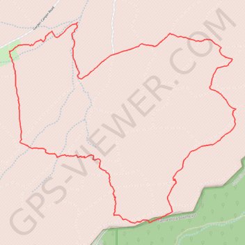
Garden Canyon Loop
Loop hike in the Garden Canyon via the Tinker Pond in the Coronado National Forest. #Hiking #Loop #Nature #Mountain #Forest #Lake
- Distance: 6.1 mi
- Elevation gain: 1,286 ft
- Maximum elevation: 5,669 ft
- Elevation loss: 1,289 ft
- Minimum elevation: 5,075 ft
- Moving time: 2 h 38 m
- Moving speed: 2.3 mph
- Maximum speed: 7.8 mph
- Total time: 3 h 6 m
- Global speed: 2.0 mph
Interactive trail map
Make a donation
Gear up for your next adventure:
As an Amazon Associate, this site earns from qualifying purchases at no extra cost to you.
Trail profile
- Distance: 6.1 mi
- Elevation gain: 1,286 ft
- Maximum elevation: 5,669 ft
- Elevation loss: 1,289 ft
- Minimum elevation: 5,075 ft
- Moving time: 2 h 38 m
- Moving speed: 2.3 mph
- Maximum speed: 7.8 mph
- Total time: 3 h 6 m
- Global speed: 2.0 mph
Make a donation
Gear up for your next adventure:
As an Amazon Associate, this site earns from qualifying purchases at no extra cost to you.
About this trail
Name: Garden Canyon Loop trail, distance, elevation, map, profile, GPS track
End: Garden Canyon Road, Sierra Vista, Cochise County, Arizona, United States (31.48019 -110.33701)
Coordinates: 31.46381 -110.33711 31.48303 -110.31169
Topography: Sierra Vista topographic map, elevation, terrain
Make a donation
Gear up for your next adventure:
As an Amazon Associate, this site earns from qualifying purchases at no extra cost to you.