Make a donation
Gear up for your next adventure:
As an Amazon Associate, this site earns from qualifying purchases at no extra cost to you.
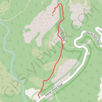
Sentinel Dome
Interactive trail map
Make a donation
Gear up for your next adventure:
As an Amazon Associate, this site earns from qualifying purchases at no extra cost to you.
Trail profile
- Distance: 1.1 mi
- Elevation gain: 436 ft
- Maximum elevation: 8,133 ft
- Elevation loss: 62 ft
- Minimum elevation: 7,720 ft
Make a donation
Gear up for your next adventure:
As an Amazon Associate, this site earns from qualifying purchases at no extra cost to you.
About this trail
Name: Sentinel Dome trail, distance, elevation, map, profile, GPS track
Start: Glacier Point Road, Mariposa County, California, 95389, United States (37.71244 -119.58634)
End: Sentinel Dome Trail, Mariposa County, California, 95389, United States (37.72316 -119.58430)
Coordinates: 37.71244 -119.58665 37.72437 -119.58249
Topography: Mariposa County topographic map, elevation, terrain
Make a donation
Gear up for your next adventure:
As an Amazon Associate, this site earns from qualifying purchases at no extra cost to you.
Other hiking, mountain biking, running and outdoor activity trails
Click on a trail to view its statistics, map and profile.
Yosemite Valley Loop
United States > California > Mariposa County > Yosemite Village
From Yosemite Village, the route slips into the Valley Loop Trail corridor, moving through the quieter village edge toward Yosemite Falls views before continuing west below the Three Brothers and into the open floor of Leidig Meadow, where forest, meadow grass, and the Merced River alternate along the way. The…
Distance: 9.2 mi • Elevation gain: 699 ft • Maximum elevation: 4,068 ft
Sentinel Dome, Glacier Point, Union Point and Taft Point Loop (Yosemite)
United States > California > Mariposa County
From Sentinel Dome Trailhead, the loop begins among conifer forest, meadow and open granite before climbing toward Sentinel Dome, where the landscape opens to broad views over Yosemite Valley, Half Dome and the high Sierra. The route then swings toward Glacier Point, one of Yosemite’s classic overlooks above…
Distance: 13.3 mi • Elevation gain: 5,827 ft • Maximum elevation: 8,130 ft
Make a donation
Gear up for your next adventure:
As an Amazon Associate, this site earns from qualifying purchases at no extra cost to you.