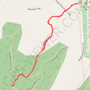
Chautauqua Trail in City of Boulder Open Space and Mountain Parks
The Chautauqua Trail in Boulder, Colorado, offers a classic introduction to the city's beloved Flatirons. Starting at the historic Chautauqua Park, the trail ascends through a mix of open meadows and shaded pine forests, providing hikers with sweeping views of Boulder, the plains, and the towering rock formations of the Flatirons, iconic sandstone formations that dominate the skyline. The route is popular year-round, offering not only a close-up look at the natural beauty of the area but also access to various other trails that wind through the foothills of the Rocky Mountains. #Hiking #Mountain #Forest #Nature
- Distance: 1.3 mi
- Elevation gain: 479 ft
- Maximum elevation: 6,178 ft
- Elevation loss: 479 ft
- Minimum elevation: 5,699 ft
- Moving time: 29 m 31 s
- Moving speed: 2.6 mph
- Maximum speed: 4.5 mph
- Total time: 30 m 46 s
- Global speed: 2.5 mph
Interactive trail map
Trail profile
- Distance: 1.3 mi
- Elevation gain: 479 ft
- Maximum elevation: 6,178 ft
- Elevation loss: 479 ft
- Minimum elevation: 5,699 ft
- Moving time: 29 m 31 s
- Moving speed: 2.6 mph
- Maximum speed: 4.5 mph
- Total time: 30 m 46 s
- Global speed: 2.5 mph
About this trail
Name: Chautauqua Trail in City of Boulder Open Space and Mountain Parks trail, distance, elevation, map, profile, GPS track
Coordinates: 39.99285 -105.28935 39.99876 -105.28312
Topography: Boulder topographic map, elevation, terrain
Other hiking, mountain biking, running and outdoor activity trails
Click on a trail to view its statistics, map and profile.
Royal Arch via Bluebell Hiking Trail, Royal Arch Trail and The Flatirons
United States > Colorado > Boulder County > Boulder
The Royal Arch Trail in Boulder offers a rewarding hike that leads you through a scenic forest with glimpses of the iconic Flatirons. While the ascent involves quite a few stairs, the effort pays off when you reach the stunning Royal Arch, where you can soak in this impressive rock formation up close. #Hiking…
Distance: 3.6 mi • Elevation gain: 1,266 ft • Maximum elevation: 6,906 ft
Chautauqua, Bluebell-Baird and Bluebell Mesa Trails Loop in Boulder Open Space and Mountain Parks
United States > Colorado > Boulder County > Boulder
The Chautauqua, Bluebell-Baird, and Bluebell Mesa Trails Loop offers a scenic and diverse hiking experience near Boulder, Colorado. The route provides striking views of the Flatirons towering above open meadows and lush woodlands, while winding through shaded ponderosa pine forests and quiet meadows. Along the…
Distance: 1.5 mi • Elevation gain: 482 ft • Maximum elevation: 6,178 ft