Make a donation
Gear up for your next adventure:
As an Amazon Associate, this site earns from qualifying purchases at no extra cost to you.
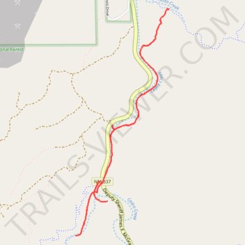
Cedro Creek Trail in Cibola National Forest
- Distance: 3.4 mi
- Elevation gain: 417 ft
- Maximum elevation: 6,663 ft
- Elevation loss: 417 ft
- Minimum elevation: 6,473 ft
- Moving time: 1 h 25 m
- Moving speed: 2.4 mph
- Maximum speed: 5.1 mph
- Total time: 1 h 31 m
- Global speed: 2.3 mph
Interactive trail map
Make a donation
Gear up for your next adventure:
As an Amazon Associate, this site earns from qualifying purchases at no extra cost to you.
Trail profile
- Distance: 3.4 mi
- Elevation gain: 417 ft
- Maximum elevation: 6,663 ft
- Elevation loss: 417 ft
- Minimum elevation: 6,473 ft
- Moving time: 1 h 25 m
- Moving speed: 2.4 mph
- Maximum speed: 5.1 mph
- Total time: 1 h 31 m
- Global speed: 2.3 mph
Make a donation
Gear up for your next adventure:
As an Amazon Associate, this site earns from qualifying purchases at no extra cost to you.
About this trail
Name: Cedro Creek Trail in Cibola National Forest trail, distance, elevation, map, profile, GPS track
Start: Tunnel Canyon Trailhead, Bernalillo County, New Mexico, 87059, United States (35.04656 -106.38305)
End: Tunnel Canyon Trailhead, Bernalillo County, New Mexico, 87059, United States (35.04655 -106.38306)
Coordinates: 35.04247 -106.38531 35.05963 -106.37665
Topography: Bernalillo County topographic map, elevation, terrain
Make a donation
Gear up for your next adventure:
As an Amazon Associate, this site earns from qualifying purchases at no extra cost to you.