Thank you for supporting this site ❤️
Make a donation
Make a donation
Gear up for your next adventure:
As an Amazon Associate, this site earns from qualifying purchases at no extra cost to you.
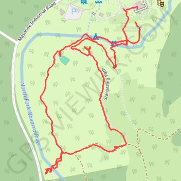
Camp Navarro hiking paths and POIs
- Distance: 1.7 mi
- Elevation gain: 253 ft
- Maximum elevation: 217 ft
- Elevation loss: 246 ft
- Minimum elevation: 115 ft
- Moving time: 43 m 58 s
- Moving speed: 2.3 mph
- Maximum speed: 4.3 mph
- Total time: 1 h 12 m
- Global speed: 1.4 mph
Interactive trail map
Thank you for supporting this site ❤️
Make a donation
Make a donation
Gear up for your next adventure:
As an Amazon Associate, this site earns from qualifying purchases at no extra cost to you.
Trail profile
- Distance: 1.7 mi
- Elevation gain: 253 ft
- Maximum elevation: 217 ft
- Elevation loss: 246 ft
- Minimum elevation: 115 ft
- Moving time: 43 m 58 s
- Moving speed: 2.3 mph
- Maximum speed: 4.3 mph
- Total time: 1 h 12 m
- Global speed: 1.4 mph
Thank you for supporting this site ❤️
Make a donation
Make a donation
Gear up for your next adventure:
As an Amazon Associate, this site earns from qualifying purchases at no extra cost to you.
About this trail
Name: Camp Navarro hiking paths and POIs trail, distance, elevation, map, profile, GPS track
Coordinates: 39.16451 -123.56909 39.17009 -123.56481
Topography: Mendocino County topographic map, elevation, terrain
Thank you for supporting this site ❤️
Make a donation
Make a donation
Gear up for your next adventure:
As an Amazon Associate, this site earns from qualifying purchases at no extra cost to you.