Make a donation
Gear up for your next adventure:
As an Amazon Associate, this site earns from qualifying purchases at no extra cost to you.
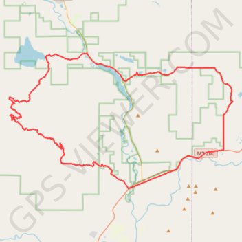
Clearwater River Loop
Morning Mountain Bike Ride
- Distance: 46.0 mi
- Elevation gain: 3,533 ft
- Maximum elevation: 5,574 ft
- Elevation loss: 3,533 ft
- Minimum elevation: 3,825 ft
- Moving time: 4 h 7 m
- Moving speed: 11.2 mph
- Maximum speed: 34.0 mph
- Total time: 4 h 38 m
- Global speed: 9.9 mph
Interactive trail map
Make a donation
Gear up for your next adventure:
As an Amazon Associate, this site earns from qualifying purchases at no extra cost to you.
Trail profile
- Distance: 46.0 mi
- Elevation gain: 3,533 ft
- Maximum elevation: 5,574 ft
- Elevation loss: 3,533 ft
- Minimum elevation: 3,825 ft
- Moving time: 4 h 7 m
- Moving speed: 11.2 mph
- Maximum speed: 34.0 mph
- Total time: 4 h 38 m
- Global speed: 9.9 mph
Make a donation
Gear up for your next adventure:
As an Amazon Associate, this site earns from qualifying purchases at no extra cost to you.
About this trail
Name: Clearwater River Loop trail, distance, elevation, map, profile, GPS track
Start: Blanchard Creek Road, Missoula County, Montana, United States (46.99634 -113.39079)
End: Blanchard Creek Road, Missoula County, Montana, United States (46.99625 -113.39068)
Coordinates: 46.99514 -113.55113 47.11991 -113.24820
Topography: Missoula County topographic map, elevation, terrain
Make a donation
Gear up for your next adventure:
As an Amazon Associate, this site earns from qualifying purchases at no extra cost to you.