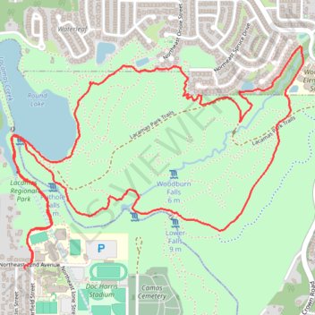
Lacamas Regional Park loop walk via Round Lake and Woodburn Park
- Distance: 4.2 mi
- Elevation gain: 453 ft
- Maximum elevation: 413 ft
- Elevation loss: 453 ft
- Minimum elevation: 174 ft
- Moving time: 1 h 14 m
- Moving speed: 3.3 mph
- Maximum speed: 7.4 mph
- Total time: 1 h 17 m
- Global speed: 3.2 mph
Interactive trail map
Trail profile
- Distance: 4.2 mi
- Elevation gain: 453 ft
- Maximum elevation: 413 ft
- Elevation loss: 453 ft
- Minimum elevation: 174 ft
- Moving time: 1 h 14 m
- Moving speed: 3.3 mph
- Maximum speed: 7.4 mph
- Total time: 1 h 17 m
- Global speed: 3.2 mph
About this trail
Name: Lacamas Regional Park loop walk via Round Lake and Woodburn Park trail, distance, elevation, map, profile, GPS track
Coordinates: 45.59487 -122.40454 45.60458 -122.38636
Topography: Clark County topographic map, elevation, terrain
Other hiking, mountain biking, running and outdoor activity trails
Click on a trail to view its statistics, map and profile.
Expedition to Sedum Ridge
United States > Oregon > Multnomah County > Portland
Distance: 133.4 mi • Elevation gain: 16,709 ft • Maximum elevation: 3,835 ft