Thank you for supporting this site ❤️
Make a donation
Make a donation
Gear up for your next adventure:
As an Amazon Associate, this site earns from qualifying purchases at no extra cost to you.
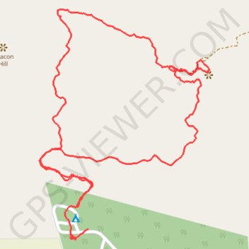
Trails at Zvakanaka
- Distance: 2.3 mi
- Elevation gain: 627 ft
- Maximum elevation: 4,678 ft
- Elevation loss: 643 ft
- Minimum elevation: 4,127 ft
- Moving time: 1 h 11 m
- Moving speed: 2.0 mph
- Maximum speed: 5.6 mph
- Total time: 1 h 28 m
- Global speed: 1.6 mph
Interactive trail map
Thank you for supporting this site ❤️
Make a donation
Make a donation
Gear up for your next adventure:
As an Amazon Associate, this site earns from qualifying purchases at no extra cost to you.
Trail profile
- Distance: 2.3 mi
- Elevation gain: 627 ft
- Maximum elevation: 4,678 ft
- Elevation loss: 643 ft
- Minimum elevation: 4,127 ft
- Moving time: 1 h 11 m
- Moving speed: 2.0 mph
- Maximum speed: 5.6 mph
- Total time: 1 h 28 m
- Global speed: 1.6 mph
Thank you for supporting this site ❤️
Make a donation
Make a donation
Gear up for your next adventure:
As an Amazon Associate, this site earns from qualifying purchases at no extra cost to you.
About this trail
Name: Trails at Zvakanaka trail, distance, elevation, map, profile, GPS track
Coordinates: -22.97680 29.95099 -22.96934 29.95698
Thank you for supporting this site ❤️
Make a donation
Make a donation
Gear up for your next adventure:
As an Amazon Associate, this site earns from qualifying purchases at no extra cost to you.