Thank you for supporting this site ❤️
Make a donation
Make a donation
Gear up for your next adventure:
As an Amazon Associate, this site earns from qualifying purchases at no extra cost to you.
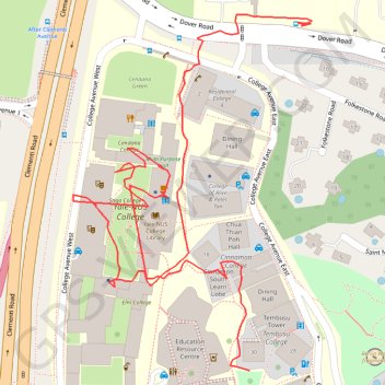
Yale NUS walking
- Distance: 0.9 mi
- Elevation gain: 102 ft
- Maximum elevation: 82 ft
- Elevation loss: 43 ft
- Minimum elevation: 13 ft
- Moving time: 19 m 28 s
- Moving speed: 2.8 mph
- Maximum speed: 20.2 mph
- Total time: 22 m 38 s
- Global speed: 2.4 mph
Interactive trail map
Thank you for supporting this site ❤️
Make a donation
Make a donation
Gear up for your next adventure:
As an Amazon Associate, this site earns from qualifying purchases at no extra cost to you.
Trail profile
- Distance: 0.9 mi
- Elevation gain: 102 ft
- Maximum elevation: 82 ft
- Elevation loss: 43 ft
- Minimum elevation: 13 ft
- Moving time: 19 m 28 s
- Moving speed: 2.8 mph
- Maximum speed: 20.2 mph
- Total time: 22 m 38 s
- Global speed: 2.4 mph
Thank you for supporting this site ❤️
Make a donation
Make a donation
Gear up for your next adventure:
As an Amazon Associate, this site earns from qualifying purchases at no extra cost to you.
About this trail
Name: Yale NUS walking trail, distance, elevation, map, profile, GPS track
Coordinates: 1.30574 103.77178 1.30910 103.77403
Thank you for supporting this site ❤️
Make a donation
Make a donation
Gear up for your next adventure:
As an Amazon Associate, this site earns from qualifying purchases at no extra cost to you.
Other hiking, mountain biking, running and outdoor activity trails
Click on a trail to view its statistics, map and profile.
The Green Corridor - Singapore
Distance: 13.8 mi • Elevation gain: 548 ft • Maximum elevation: 144 ft
Directions from Duck Tour Ramp to Marina Boulevard, Singapore
Distance: 65.5 mi • Elevation gain: 2,664 ft • Maximum elevation: 167 ft