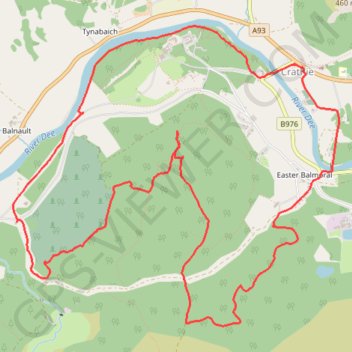
Balmoral Castle
- Distance: 6.3 mi
- Elevation gain: 951 ft
- Maximum elevation: 1,430 ft
- Elevation loss: 951 ft
- Minimum elevation: 879 ft
- Moving time: 2 h 28 m
- Moving speed: 2.5 mph
- Maximum speed: 12.5 mph
- Total time: 3 h 53 m
- Global speed: 1.6 mph
Interactive trail map
Trail profile
- Distance: 6.3 mi
- Elevation gain: 951 ft
- Maximum elevation: 1,430 ft
- Elevation loss: 951 ft
- Minimum elevation: 879 ft
- Moving time: 2 h 28 m
- Moving speed: 2.5 mph
- Maximum speed: 12.5 mph
- Total time: 3 h 53 m
- Global speed: 1.6 mph
About this trail
Name: Balmoral Castle trail, distance, elevation, map, profile, GPS track
Start: B976, Crathie, Aberdeenshire, Scotland, AB35 5TL, United Kingdom (57.03992 -3.21532)
End: B976, Crathie, Aberdeenshire, Scotland, AB35 5TL, United Kingdom (57.03994 -3.21523)
Coordinates: 57.02361 -3.24747 57.04230 -3.21013
Other hiking, mountain biking, running and outdoor activity trails
Click on a trail to view its statistics, map and profile.
Balmoral Estate
United Kingdom > Scotland > Aberdeenshire > Crathie > Easter Balmoral
Mountain Bike Ride #UK #Aberdeenshire #BalmoralEstate
Distance: 11.6 mi • Elevation gain: 988 ft • Maximum elevation: 1,434 ft