Make a donation
Gear up for your next adventure:
As an Amazon Associate, this site earns from qualifying purchases at no extra cost to you.
Munro hillwalk Strathfarrar Rguidhe Gobhar Ghlais Fhuar-thuill
Munro, hillwalk, Strathfarrar, Rguidhe, Gobhar, Ghlais, Fhuar-thuill
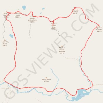
- Distance: 16.9 mi
- Elevation gain: 5,404 ft
- Maximum elevation: 3,530 ft
- Elevation loss: 5,404 ft
- Minimum elevation: 436 ft
- Moving time: 7 h 7 m
- Moving speed: 2.4 mph
- Maximum speed: 18.9 mph
- Total time: 8 h 7 m
- Global speed: 2.1 mph
Interactive trail map
Make a donation
Gear up for your next adventure:
As an Amazon Associate, this site earns from qualifying purchases at no extra cost to you.
Trail profile
- Distance: 16.9 mi
- Elevation gain: 5,404 ft
- Maximum elevation: 3,530 ft
- Elevation loss: 5,404 ft
- Minimum elevation: 436 ft
- Moving time: 7 h 7 m
- Moving speed: 2.4 mph
- Maximum speed: 18.9 mph
- Total time: 8 h 7 m
- Global speed: 2.1 mph
Make a donation
Gear up for your next adventure:
As an Amazon Associate, this site earns from qualifying purchases at no extra cost to you.
About this trail
Name: Munro hillwalk Strathfarrar Rguidhe Gobhar Ghlais Fhuar-thuill trail, distance, elevation, map, profile, GPS track
Start: Glencannich Road, Cannich, Highland, Scotland, IV4 7LX, United Kingdom (57.40571 -4.85932)
End: Glencannich Road, Cannich, Highland, Scotland, IV4 7LX, United Kingdom (57.40563 -4.85931)
Coordinates: 57.39922 -4.95860 57.45231 -4.85245
Make a donation
Gear up for your next adventure:
As an Amazon Associate, this site earns from qualifying purchases at no extra cost to you.
Other hiking, mountain biking, running and outdoor activity trails
Click on a trail to view its statistics, map and profile.
Loch Ness
United Kingdom > Scotland > Highland > Lochcarron
Distance: 66.3 mi • Elevation gain: 5,197 ft • Maximum elevation: 919 ft