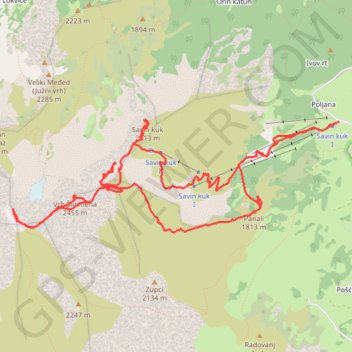
Savin kuk 2313 - Šljeme istočni vrh 2445 - Vrh Šljemena 2455...
- Distance: 8.4 mi
- Elevation gain: 4,209 ft
- Maximum elevation: 8,009 ft
- Elevation loss: 4,213 ft
- Minimum elevation: 4,961 ft
- Moving time: 4 h 54 s
- Moving speed: 2.1 mph
- Maximum speed: 7.2 mph
- Total time: 4 h 45 m
- Global speed: 1.8 mph
Interactive trail map
Trail profile
- Distance: 8.4 mi
- Elevation gain: 4,209 ft
- Maximum elevation: 8,009 ft
- Elevation loss: 4,213 ft
- Minimum elevation: 4,961 ft
- Moving time: 4 h 54 s
- Moving speed: 2.1 mph
- Maximum speed: 7.2 mph
- Total time: 4 h 45 m
- Global speed: 1.8 mph
About this trail
Name: Savin kuk 2313 - Šljeme istočni vrh 2445 - Vrh Šljemena 2455... trail, distance, elevation, map, profile, GPS track
Coordinates: 43.11285 19.06451 43.12287 19.10414
Other hiking, mountain biking, running and outdoor activity trails
Click on a trail to view its statistics, map and profile.
2022_Yu
Slovenia > Ajdovščina > Žapuže
Distance: 1,526.9 mi • Elevation gain: 105,144 ft • Maximum elevation: 6,398 ft
MNE-3: Sedlo - Bobotov kuk - Ice Cave - Crno jezero
Montenegro > Žabljak Municipality > Pašina voda > Pošćenski katun
Distance: 9.0 mi • Elevation gain: 3,232 ft • Maximum elevation: 7,927 ft