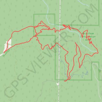
Mica Peak Conservation Area hike
- Distance: 11.9 mi
- Elevation gain: 2,438 ft
- Maximum elevation: 4,531 ft
- Elevation loss: 2,438 ft
- Minimum elevation: 2,717 ft
- Moving time: 3 h 59 m
- Moving speed: 3.0 mph
- Maximum speed: 7.4 mph
- Total time: 5 h 21 m
- Global speed: 2.2 mph
Interactive trail map
Trail profile
- Distance: 11.9 mi
- Elevation gain: 2,438 ft
- Maximum elevation: 4,531 ft
- Elevation loss: 2,438 ft
- Minimum elevation: 2,717 ft
- Moving time: 3 h 59 m
- Moving speed: 3.0 mph
- Maximum speed: 7.4 mph
- Total time: 5 h 21 m
- Global speed: 2.2 mph
About this trail
Name: Mica Peak Conservation Area hike trail, distance, elevation, map, profile, GPS track
Coordinates: 47.56534 -117.13547 47.58509 -117.08960
Topography: Spokane County topographic map, elevation, terrain