Thank you for supporting this site ❤️
Make a donation
Make a donation
Gear up for your next adventure:
As an Amazon Associate, this site earns from qualifying purchases at no extra cost to you.
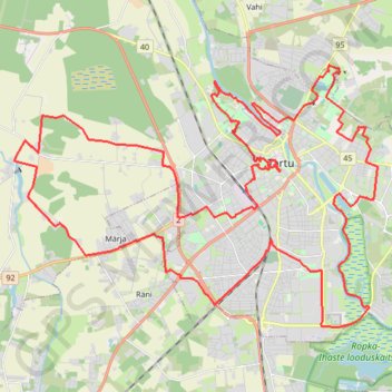
Kondimootor 50 KM (Tartu 2023)
Route created on plotaroute.com
- Distance: 31.1 mi
- Elevation gain: 732 ft
- Maximum elevation: 256 ft
- Elevation loss: 732 ft
- Minimum elevation: 95 ft
- Moving time: 10 h 2 m
- Moving speed: 3.1 mph
- Maximum speed: 3.3 mph
- Total time: 10 h 2 m
- Global speed: 3.1 mph
Interactive trail map
Thank you for supporting this site ❤️
Make a donation
Make a donation
Gear up for your next adventure:
As an Amazon Associate, this site earns from qualifying purchases at no extra cost to you.
Trail profile
- Distance: 31.1 mi
- Elevation gain: 732 ft
- Maximum elevation: 256 ft
- Elevation loss: 732 ft
- Minimum elevation: 95 ft
- Moving time: 10 h 2 m
- Moving speed: 3.1 mph
- Maximum speed: 3.3 mph
- Total time: 10 h 2 m
- Global speed: 3.1 mph
Thank you for supporting this site ❤️
Make a donation
Make a donation
Gear up for your next adventure:
As an Amazon Associate, this site earns from qualifying purchases at no extra cost to you.
About this trail
Name: Kondimootor 50 KM (Tartu 2023) trail, distance, elevation, map, profile, GPS track
End: 25, Laulupeo pst, Tähtvere, Tartu, Tartu linn, Tartu County, 51006, Estonia (58.38838 26.70311)
Coordinates: 58.34252 26.60661 58.40244 26.76491
Thank you for supporting this site ❤️
Make a donation
Make a donation
Gear up for your next adventure:
As an Amazon Associate, this site earns from qualifying purchases at no extra cost to you.