Thank you for supporting this site ❤️
Make a donation
Make a donation
Gear up for your next adventure:
As an Amazon Associate, this site earns from qualifying purchases at no extra cost to you.
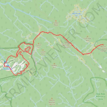
Snow Gum Run Mount Baw Baw
- Distance: 9.4 mi
- Elevation gain: 1,526 ft
- Maximum elevation: 5,098 ft
- Elevation loss: 1,526 ft
- Minimum elevation: 4,734 ft
- Moving time: 2 h 26 m
- Moving speed: 3.8 mph
- Maximum speed: 8.4 mph
- Total time: 2 h 26 m
- Global speed: 3.8 mph
Interactive trail map
Thank you for supporting this site ❤️
Make a donation
Make a donation
Gear up for your next adventure:
As an Amazon Associate, this site earns from qualifying purchases at no extra cost to you.
Trail profile
- Distance: 9.4 mi
- Elevation gain: 1,526 ft
- Maximum elevation: 5,098 ft
- Elevation loss: 1,526 ft
- Minimum elevation: 4,734 ft
- Moving time: 2 h 26 m
- Moving speed: 3.8 mph
- Maximum speed: 8.4 mph
- Total time: 2 h 26 m
- Global speed: 3.8 mph
Thank you for supporting this site ❤️
Make a donation
Make a donation
Gear up for your next adventure:
As an Amazon Associate, this site earns from qualifying purchases at no extra cost to you.
About this trail
Name: Snow Gum Run Mount Baw Baw trail, distance, elevation, map, profile, GPS track
Coordinates: -37.84413 146.26455 -37.82778 146.31125
Thank you for supporting this site ❤️
Make a donation
Make a donation
Gear up for your next adventure:
As an Amazon Associate, this site earns from qualifying purchases at no extra cost to you.
Other hiking, mountain biking, running and outdoor activity trails
Click on a trail to view its statistics, map and profile.
Traralgon - Walhalla - Woods Point
Australia > Victoria > Traralgon
#Bike
Distance: 77.4 mi • Elevation gain: 13,970 ft • Maximum elevation: 3,822 ft
Moe - Woods Point
#Bike
Distance: 67.8 mi • Elevation gain: 10,810 ft • Maximum elevation: 3,822 ft