Make a donation
Gear up for your next adventure:
As an Amazon Associate, this site earns from qualifying purchases at no extra cost to you.
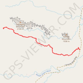
Cathedrals Trail
Hike along the Cathedrals Trail in the Cathedral Valley and the Capitol Reef National Park. #Hiking #Nature #Park
- Distance: 2.5 mi
- Elevation gain: 413 ft
- Maximum elevation: 6,722 ft
- Elevation loss: 413 ft
- Minimum elevation: 6,394 ft
- Moving time: 1 h 7 m
- Moving speed: 2.2 mph
- Maximum speed: 2.4 mph
- Total time: 1 h 7 m
- Global speed: 2.2 mph
Interactive trail map
Make a donation
Gear up for your next adventure:
As an Amazon Associate, this site earns from qualifying purchases at no extra cost to you.
Trail profile
- Distance: 2.5 mi
- Elevation gain: 413 ft
- Maximum elevation: 6,722 ft
- Elevation loss: 413 ft
- Minimum elevation: 6,394 ft
- Moving time: 1 h 7 m
- Moving speed: 2.2 mph
- Maximum speed: 2.4 mph
- Total time: 1 h 7 m
- Global speed: 2.2 mph
Make a donation
Gear up for your next adventure:
As an Amazon Associate, this site earns from qualifying purchases at no extra cost to you.
About this trail
Name: Cathedrals Trail trail, distance, elevation, map, profile, GPS track
Start: Caineville Wash Road, Caineville, Wayne County, Utah, United States (38.48799 -111.35321)
End: Cathedrals Trail, Wayne County, Utah, United States (38.48797 -111.35325)
Coordinates: 38.48694 -111.37030 38.49194 -111.35321
Topography: Wayne County topographic map, elevation, terrain
Make a donation
Gear up for your next adventure:
As an Amazon Associate, this site earns from qualifying purchases at no extra cost to you.