Thank you for supporting this site ❤️
Make a donation
Make a donation
Gear up for your next adventure:
As an Amazon Associate, this site earns from qualifying purchases at no extra cost to you.
Bear Hollow Trail
Interactive trail map
Thank you for supporting this site ❤️
Make a donation
Make a donation
Gear up for your next adventure:
As an Amazon Associate, this site earns from qualifying purchases at no extra cost to you.
Trail profile
- Distance: 5.0 mi
- Elevation gain: 712 ft
- Maximum elevation: 2,320 ft
- Elevation loss: 709 ft
- Minimum elevation: 2,146 ft
Thank you for supporting this site ❤️
Make a donation
Make a donation
Gear up for your next adventure:
As an Amazon Associate, this site earns from qualifying purchases at no extra cost to you.
About this trail
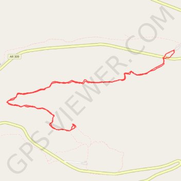
Name: Bear Hollow Trail trail, distance, elevation, map, profile, GPS track
Start: Will Apple's Road Trail, Logan County, Arkansas, United States (35.17639 -93.59285)
End: Will Apple's Road Trail, Logan County, Arkansas, United States (35.17646 -93.59286)
Coordinates: 35.16673 -93.61751 35.17646 -93.59285
Topography: Logan County topographic map, elevation, terrain
Thank you for supporting this site ❤️
Make a donation
Make a donation
Gear up for your next adventure:
As an Amazon Associate, this site earns from qualifying purchases at no extra cost to you.