Thank you for supporting this site ❤️
Make a donation
Make a donation
Gear up for your next adventure:
As an Amazon Associate, this site earns from qualifying purchases at no extra cost to you.
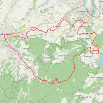
Trasa z 49.853114N, 19.343233E do 49.853100N, 19.343201E
- Distance: 30.4 mi
- Elevation gain: 3,442 ft
- Maximum elevation: 2,785 ft
- Elevation loss: 3,442 ft
- Minimum elevation: 873 ft
Interactive trail map
Thank you for supporting this site ❤️
Make a donation
Make a donation
Gear up for your next adventure:
As an Amazon Associate, this site earns from qualifying purchases at no extra cost to you.
Trail profile
- Distance: 30.4 mi
- Elevation gain: 3,442 ft
- Maximum elevation: 2,785 ft
- Elevation loss: 3,442 ft
- Minimum elevation: 873 ft
Thank you for supporting this site ❤️
Make a donation
Make a donation
Gear up for your next adventure:
As an Amazon Associate, this site earns from qualifying purchases at no extra cost to you.
About this trail
Name: Trasa z 49.853114N, 19.343233E do 49.853100N, 19.343201E trail, distance, elevation, map, profile, GPS track
Coordinates: 49.79390 19.34235 49.87430 19.52441
Thank you for supporting this site ❤️
Make a donation
Make a donation
Gear up for your next adventure:
As an Amazon Associate, this site earns from qualifying purchases at no extra cost to you.